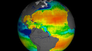
These tangy tracts have been revealed by NASA's Aquarius instrument, which is aboard Argentina's Aquarius/SAC-D spacecraft and is dedicated to studying the salt content of the oceans.
NASA has just released the first year of data from Aquarius, running from December 2011 to December 2012. In the image above, red and orange areas are very salty, while green and blue areas are less so.
Patterns of salinity are expected to change over the coming decades as the climate shifts, with knock-on effects for major currents and regional sea level rise. More here.

1 comment:
I didn't expect somebody to actually develop this kind of thing but it's absolutely brilliant, props to the people behind this.
Post a Comment